UPDATE
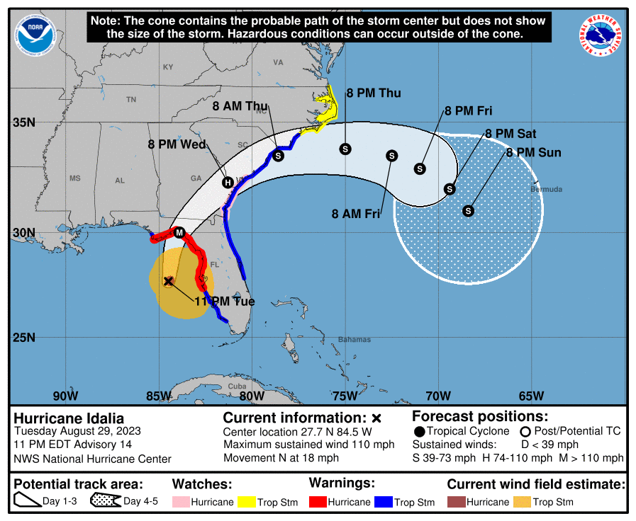
11:00 pm EST Update from National Weather Center
IDALIA STILL STRENGTHENING… …FORECAST TO BE AN EXTREMELY DANGEROUS CATEGORY 4 INTENSITY AT LANDFALL…
At 1100 PM EDT (0300 UTC), the center of Hurricane Idalia was located near latitude 27.7 North, longitude 84.5 West. Idalia is moving toward the north near 18 mph (30 km/h). A northward to north-northeastward motion is expected through tonight, with Idalia’s center forecast to reach the Big Bend coast of Florida on Wednesday morning. After landfall, the center of Idalia is forecast to turn toward the northeast and east-northeast, moving near or along the coasts of Georgia, South Carolina, and North Carolina late Wednesday and Thursday. Hurricane Hunter aircraft data indicate that maximum sustained winds are near 110 mph (175 km/h) with higher gusts. Additional strengthening is forecast, and Idalia is expected to become a major hurricane during the next few hours before it reaches the Big Bend coast of Florida. Idalia is likely to still be a hurricane while moving across southern Georgia, and possibly when it reaches the coast of Georgia or southern South Carolina on Wednesday.
————
UPDATE
5:00 EST Update from National Weather Center IDALIA NOW A CATEGORY 2 HURRICANE… …LIFE-THREATENING STORM SURGE AND HURRICANE CONDITIONS EXPECTED ALONG PORTIONS OF THE GULF COAST OF FLORIDA TONIGHT AND WEDNESDAY…
UPDATE
2:00 pm EST Update from National Hurricane Center
IDALIA’S SQUALLS OVERSPREADING PORTIONS OF THE LOWER FLORIDA KEYS AND THE SOUTHWESTERN COAST OF FLORIDA… …LIFE-THREATENING STORM SURGE AND HURRICANE CONDITIONS EXPECTED ALONG PORTIONS OF THE GULF COAST OF FLORIDA TONIGHT AND WEDNESDAY…
MAXIMUM SUSTAINED WINDS…90 MPH…150 KM/H PRESENT MOVEMENT…N OR 360 DEGREES AT 15 MPH…24 KM/H MINIMUM CENTRAL PRESSURE…974 MB…28.76 INCHES
————
UPDATE
11:00 am EST Update from National Hurricane Center
IDALIA STRENGTHENING… …LIFE-THREATENING STORM SURGE AND HURRICANE CONDITIONS EXPECTED ALONG PORTIONS OF THE GULF COAST OF FLORIDA TONIGHT AND WEDNESDAY.
MAXIMUM SUSTAINED WINDS…85 MPH…140 KM/H PRESENT MOVEMENT…N OR 5 DEGREES AT 14 MPH…22 KM/H MINIMUM CENTRAL PRESSURE…976 MB…28.82 INCHES
—————
UPDATE
5:00 am EST Update from National Hurricane Center
IDALIA NOW A HURRICANE… …EXPECTED TO RAPIDLY INTENSIFY INTO AN EXTREMELY DANGEROUS MAJOR HURRICANE BEFORE LANDFALL ON WEDNESDAY…
MAXIMUM SUSTAINED WINDS…75 MPH…120 KM/H PRESENT MOVEMENT…N OR 360 DEGREES AT 14 MPH…22 KM/H MINIMUM CENTRAL PRESSURE…981 MB…28.97 INCHES
—————
UPDATE
8:00 pm EST Update from National Hurricane Center
2023 …IDALIA ALMOST A HURRICANE NEAR THE WESTERN TIP OF CUBA… …LIFE-THREATENING STORM SURGE AND DANGEROUS WINDS BECOMING INCREASINGLY LIKELY FOR PORTIONS OF FLORIDA…
MAXIMUM SUSTAINED WINDS…70 MPH…110 KM/H PRESENT MOVEMENT…N OR 360 DEGREES AT 8 MPH…13 KM/H MINIMUM CENTRAL PRESSURE…983 MB…29.03 INCHES
————
UPDATE
5:00 pm EST Update from National Hurricane Center
…IDALIA NEARING HURRICANE STRENGTH AS IT APPROACHES WESTERN CUBA… …LIFE-THREATENING STORM SURGE AND DANGEROUS WINDS BECOMING INCREASINGLY LIKELY FOR PORTIONS OF FLORIDA…
MAXIMUM SUSTAINED WINDS…70 MPH…110 KM/H PRESENT MOVEMENT…N OR 360 DEGREES AT 8 MPH…13 KM/H MINIMUM CENTRAL PRESSURE…987 MB…29.15 INCHES
The Storm Surge Warning has been extended westward to Indian Pass Florida. The Hurricane Warning has also been extended westward to Indian Pass. A Tropical Storm Warning has been issued from west of Indian Pass westward to Mexico Beach. The Storm Surge Watch along the southeast coast of the United States has been extended northward to South Santee River. The Tropical Storm Watch along the southeast coast of the United States has been extended northward to South Santee River.
————
2:00 EST Update from National Hurricane Center
…IDALIA STRENGTHENING AS IT NEARS THE WESTERN TIP OF CUBA… …LIFE-THREATENING STORM SURGE AND DANGEROUS WINDS BECOMING INCREASINGLY LIKELY FOR PORTIONS OF FLORIDA…
SUSTAINED WINDS…70 MPH…110 KM/H PRESENT MOVEMENT…N OR 360 DEGREES AT 8 MPH…13 KM/H MINIMUM CENTRAL PRESSURE…987 MB…29.15 INCHES
————-
UPDATE
Polk County Emergency Management
Idalia is forecast to become a hurricane later today and a dangerous major hurricane over the northeastern Gulf of Mexico by early Wednesday. Tropical-storm-force winds extend outward up to 105 miles. Emergency Management is staffing the EOC from 7:00 a.m. – 7:00 p.m. to monitor this storm.
—————
At 5:00 a.m. Monday, Idalia is forecast to increase in forward speed and turn north-northeastward over the eastern Gulf of Mexico Tuesday and reach the Gulf coast of Florida on Wednesday. Maximum sustained winds have increased to near 65 mph with higher gusts. Idalia is forecast to become a hurricane later today and a dangerous major hurricane over northeastern Gulf of Mexico by early Wednesday.
The cone contains the probable path of the storm. Hazardous conditions can occur outside the cone. Polk County Emergency Management is monitoring this tropical storm.


